
What is a Sharrow?
A Sharrow is a shared lane marking consisting of a bicycle symbol with two chevron markings above the bicycle.

What Does it Mean?
A sharrow is used indicate a cyclist's lateral position on lanes of substandard width that will not allow an automobile and bicycle to safely travel within the same lane and also have a maximum speed limits of 35 MPH.

Note: Florida Law already gives a cyclist the rights to control the lane of substandard width. Unfortunately most cyclists and virtually no drivers are aware of this. This is the real benefit of a Sharrow.
316.2065
(5)(a) Any person operating a bicycle upon a roadway at less than the normal speed of traffic at the time and place and under the conditions then existing shall ride in the lane marked for bicycle use or, if no lane is marked for bicycle use, as close as practicable to the right-hand curb or edge of the roadway except under any of the following situations:
3. When reasonably necessary to avoid any condition, including, but not limited to, a fixed or moving object, parked or moving vehicle, bicycle, pedestrian, animal, surface hazard, or substandard-width lane, that makes it unsafe to continue along the right-hand curb or edge. For the purposes of this subsection, a “substandard-width lane” is a lane that is too narrow for a bicycle and another vehicle to travel safely side by side within the lane.
How Do I Use Them?
As explained above, Sharrows mark the lateral positioning of a cyclist, moving you into the lane of travel and forcing following traffic to change lanes to pass or wait until they can safely do so. If you look at the image below you'll see that you should be positioned somewhere between the center of the lane and where the right tire of a vehicle would be.

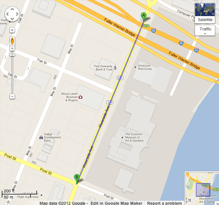
Where Are These New Sharrows Going to Be?
FDOT will placing the new Shared lane markings On Riverside Ave. from Gilmore St. to Post St. It's a short test area yes, but it helps cyclists on that narrow section of Riverside Ave. in front of the Cummer Museum and Riverside Arts Market.
Are These the First Sharrows in Jacksonville?
Short answer, no. The city did their own test last year on Loretto Rd. between Old St. Augustine Rd. and San Jose Blvd. I never posted about them because as usual with the COJ they didn't quite get them right the first time.

A COJ spokesperson told me that Sharrows have two meanings, 1 to indicate that it is shared lane 2 to show lane position for the cyclist. They are correct in the statement, but not in the principal in which they are applied. First of all, all road markings and road signage have only one defining purpose. Period. If markings and signage had more than one meaning, how would anyone know which of meanings the markings or signage was telling you?
Second issue; Here are the exact guidelines for Sharrows as laid out by the Manual on Uniform Traffic Control Devices (MUTCD).
Section 9C.07 Shared Lane Marking
Option:
The Shared Lane Marking shown in Figure 9C-9 may be used to:
A. Assist bicyclists with lateral positioning in a shared lane with on-street parallel parking in order to reduce
the chance of a bicyclist’s impacting the open door of a parked vehicle,
B. Assist bicyclists with lateral positioning in lanes that are too narrow for a motor vehicle and a bicycle to
travel side by side within the same traffic lane,
C. Alert road users of the lateral location bicyclists are likely to occupy within the traveled way,
D. Encourage safe passing of bicyclists by motorists, and
E. Reduce the incidence of wrong-way bicycling.
Guidance:
The Shared Lane Marking should not be placed on roadways that have a speed limit above 35 mph.
Standard:
Shared Lane Markings shall not be used on shoulders or in designated bicycle lanes.
Guidance:
If used in a shared lane with on-street parallel parking, Shared Lane Markings should be placed so that the centers of the markings are at least 11 feet from the face of the curb, or from the edge of the pavement where there is no curb.
If used on a street without on-street parking that has an outside travel lane that is less than 14 feet wide, the centers of the Shared Lane Markings should be at least 4 feet from the face of the curb, or from the edge of the pavement where there is no curb.
If used, the Shared Lane Marking should be placed immediately after an intersection and spaced at intervals not greater than 250 feet thereafter.
Option:
Section 9B.06 describes a Bicycles May Use Full Lane sign that may be used in addition to or instead of the Shared Lane Marking to inform road users that bicyclists might occupy the travel lane.
Notice the position of the Sharrow in the picture above. Now read the first bolded passage under Guidance. "Markings shall not be used on shoulders or in designated bicycle lanes"
Now in fairness to COJ the MUTCD Guidelines do suggest a placement of "at least 4 feet from the face of the curb, or from the edge of the pavement where there is no curb." of which the center of the placed Sharrows are exactly 4 feet from the face of the curb. I know because I measured. But the problem is the MUTCD uses a word planners and engineers don't know, "Guidance." Seeing as how planners and engineers are used to things being "Mandated", and not suggested, thinking on their own and commonsense tends to be lacking within these two communities. I'm not saying that I think planners or engineers are stupid, I'm saying that they are so used to working within very strict perimeters and thinking outside of them will tend to get said planner or engineer in massive hot water.
There you have it. You are fully informed on what and how to use Sharrows. Again, please share the link to this and lets get the word out on these new markings to as many people as possible.
2 comments:
This is a great start. Any plans to expand these through out Riverside. There is still no truly bike friendly way to get from Avondale to 5 points.
Dr., There are plans. Look for a post shortly on what they are.
Try Oak St. That is the main bike corridor between Riverside & Avondale.
Post a Comment